File:Topographic map example.png
Jump to navigation
Jump to search


No higher resolution available.
Topographic_map_example.png (600 × 600 pixels, file size: 152 KB, MIME type: image/png)
| This is a file from the Wikimedia Commons. Information from its description page there is shown below. Commons is a freely licensed media file repository. You can help. |
Summary
Esperanto: La bildo estas kopiita de wikipedia:en. La originala priskribo estas:
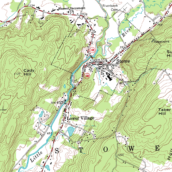
English: An inset from the USGS topographic map of Stowe, Vermont, USA, featuring 20-foot (6.096 m) contour intervals. The scale is 1:24,000.
עברית: מפה טופוגרפית באדיבות USGS.
במפה בולטים קוי הגובה (בצבע אדמדם) הנותנים תמונה תלת מימדית למי שיודע לפענח אותם. בהפרש של כל מאה מטרים, קו הגובה בולט ולידו כתוב מספרו. מצד שמאל ניתן לראות את גבעת קאדי שגובה פסגתה הוא 1122 מטר. במרכז המפה אפשר לראות נחל (בתכלת) שעובר בגיא, מכיוון צפון-מזרח לדרום-מערב. במרכז הגיא יש מאגר מים המסומן בתכלת. כמו כן ניתן לראות במפה רשת של כבישים (קו אדום לבן), ולידם בתים (קוביות שחורות). עוד במפה שבילים העולים אל הגבעות. (קוים שחורים מקווקוים).
Licensing
Source: Sample taken from the public domain USGS Digital Raster Graphic file o44072d6.tif for the Stowe, VT quadrangle
This image is in the public domain in the United States because it only contains materials that originally came from the United States Geological Survey, an agency of the United States Department of the Interior. For more information, see the official USGS copyright policy.
|
| date/time | username | edit summary |
|---|---|---|
| 23:13, 12 December 2005 | en:User:Rcc105 | (adding name of quad) |
| 21:19, 3 October 2004 | en:User:BrokenSegue | (usgs) |
| 06:20, 4 June 2004 | en:User:Template namespace initialisation script | |
| 14:34, 12 May 2004 | en:User:Redjar | (added description and source information) |
| 14:23, 12 May 2004 | en:User:Redjar | (example of a topographic map) |
Original upload log
Legend: (cur) = this is the current file, (del) = delete this old version, (rev) = revert to this old version.
Click on date to download the file or see the image uploaded on that date.
- (del) (cur) 11:23, 30 September 2005 . . en:User:Riumplus Riumplus ( en:User_talk:Riumplus Talk) . . 600x600 (155211 bytes) (Losslessly recompressed the image, shrinking file size by 5% (gAMA chunk preserved))
- (del) (rev) 14:23, 12 May 2004 . . en:User:Redjar Redjar ( en:User_talk:Redjar Talk) . . 600x600 (160792 bytes) (example of a topographic map)
File history
Click on a date/time to view the file as it appeared at that time.
| Date/Time | Thumbnail | Dimensions | User | Comment | |
|---|---|---|---|---|---|
| current | 18:24, 18 March 2006 | | 600 × 600 (152 KB) | Maksim | La bildo estas kopiita de wikipedia:en. La originala priskribo estas: '''Description:''' Example of a topographic map with contour intervals '''Source:''' Sample taken from the public domain USGS Digital Raster Graphic file o44072d6.tif for the Stowe, V |
File usage
More than 100 pages use this file. The following list shows the first 100 pages that use this file only. A full list is available.
- Contour line
- Digital raster graphic
- Map
- Stowe, Vermont
- Topographic map
- Topography
- Talk:Abraham Ortelius
- Talk:Acre
- Talk:Amerigo Vespucci
- Talk:Atlas (topology)
- Talk:Autodesk
- Talk:Biological anthropology
- Talk:Cardinal direction
- Talk:Cartogram
- Talk:Cartography
- Talk:Ceuta border fence
- Talk:Conformal map
- Talk:County of Ribagorza
- Talk:Craig retroazimuthal projection
- Talk:David Thompson (explorer)
- Talk:Dell'Arcano del Mare
- Talk:Digital raster graphic
- Talk:Domesday Book
- Talk:Durand Line
- Talk:Dymaxion map
- Talk:Fictitious entry
- Talk:Figure of the Earth
- Talk:Four color theorem
- Talk:Frame of reference
- Talk:Frontier
- Talk:Furlong
- Talk:Gall–Peters projection
- Talk:Gauss–Krüger coordinate system
- Talk:Gazetteer
- Talk:General Electric
- Talk:Geodesy
- Talk:Geographers' A–Z Street Atlas
- Talk:Geographic information system
- Talk:Geographical pole
- Talk:Georg Joachim Rheticus
- Talk:Gerardus Mercator
- Talk:Gim Jeong-ho
- Talk:Giovanni Battista Riccioli
- Talk:Giovanni Domenico Cassini
- Talk:Global Positioning System
- Talk:Horizon
- Talk:Horizontal coordinate system
- Talk:Inō Tadataka
- Talk:Irish grid reference system
- Talk:James Cook
- Talk:Jesusland map
- Talk:Johann Friedrich Endersch
- Talk:Johann Homann
- Talk:Johannes Hevelius
- Talk:Joseph Frederick Wallet DesBarres
- Talk:Karen Wynn Fonstad
- Talk:Lewis Fry Richardson
- Talk:List of cartographers
- Talk:MapQuest
- Talk:Map projection
- Talk:Map wiki
- Talk:Mappa mundi
- Talk:Martin Waldseemüller
- Talk:Melway
- Talk:Metes and bounds
- Talk:Metre
- Talk:Mile
- Talk:Mind map
- Talk:Mollweide projection
- Talk:Muhammad al-Idrisi
- Talk:Muhammad ibn Musa al-Khwarizmi
- Talk:Navigation
- Talk:Opisometer
- Talk:Petrus Plancius
- Talk:Piri Reis
- Talk:Rhumb line
- Talk:Robert Dudley (explorer)
- Talk:Samuel Holland
- Talk:Sea level
- Talk:Spherical Earth
- Talk:Stereographic projection
- Talk:Swisstopo
- Talk:Theodolite
- Talk:Thomas Guide
- Talk:Thomas Mackenzie
- Talk:Transverse Mercator projection
- Talk:Triangulation
- Talk:Tube map
- Talk:Vinland map
- Talk:William Smith (geologist)
- User:Datapacrat
- User:IsarSteve
- User:Jakro64
- User:LinasLit
- User:Ottergoose
- User:Paedia
- User:Starfarmer
- Wikipedia:WikiProject Maps
- File talk:Distribution of Races on the Balkans in 1923.jpg
- File talk:Many Karelias.png
Global file usage
The following other wikis use this file:
- Usage on ar.wikipedia.org
- Usage on ast.wikipedia.org
- Usage on azb.wikipedia.org
- Usage on az.wikipedia.org
- Usage on be-tarask.wikipedia.org
- Usage on be.wikipedia.org
- Usage on bg.wikipedia.org
- Usage on bs.wikipedia.org
- Usage on ca.wikipedia.org
- Usage on ckb.wikipedia.org
- Usage on cs.wikipedia.org
- Usage on cy.wikipedia.org
- Usage on da.wikipedia.org
- Usage on de.wikipedia.org
- Usage on el.wikipedia.org
- Usage on en.wikibooks.org
- Usage on en.wikivoyage.org
- Usage on eo.wikipedia.org
- Usage on es.wikipedia.org
- Usage on et.wikipedia.org
- Usage on eu.wikipedia.org
- Usage on fa.wikipedia.org
- Usage on fi.wikipedia.org
- Usage on fr.wikipedia.org
View more global usage of this file.